Walks
Froggatt Edge (short) walk
Distance: 9 miles switch to the long version of this walk
Terrain: Very good terrain with a climb to 340m
Location: Near Bakewell, Derbyshire
View the route
Map: Explorer OL24 (White Peak)
My last walk: 26 Jan 2013
 For this walk and the longer version, I suggest parking at Baslow SK258721 - it's pay and display and has public conveniences. It's a short walk across the road and up a residential street before you're in the countryside.
This walk can be enjoyed either way round. Taking the Derwent riverside walk first and saving the best views for last, or getting straight up there and enjoying the flat riverside walk as a warm-down with those high edges in view.
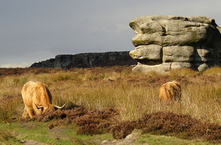
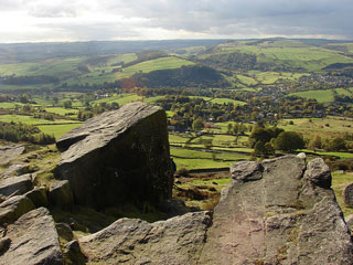 The views from Curbar Edge and Froggatt Edge are spectacular and worth the climb. In fact there is a car park really close to the edge itself but please don't take that easy shortcut. A veiw like this is so much better when you've earned it.
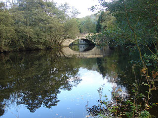 At SK255775 you have a choice of turning around and retracing your steps, or nipping down into the Derwent valley and using the Derwent Valley Heritage Trail for the return loop. The latter is well-signed and it's enjoyable to see above you the silhouette of the edge you've just walked.
blog posts about this walk:
- (long version) http://peacockmedia.blogspot.com/2007/08/froggat-edge.html
- (short version) http://peacockmedia.blogspot.com/2010/10/curbar-edge-and-froggatt-edge-in-autumn.html
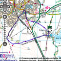
View the route
The link to the right will show you an interactive map with the route shown on it, provided free to you at this level of detail by the lovely folk at OS. The detail on it will be the equivalent of the Landranger map (1:50,000). For the full detail and a map you can carry around the walk with you, you will need an explorer (1:25,000) map. Please use the link below to buy a copy.
This walk uses Ordnance Survey map Explorer OL24 (White Peak)
Unlimited listening to thousands of titles:
