Walks
Froggatt Edge (long) walk
Distance: 20 miles switch to the short version of this walk
Terrain: Very good terrain with a climb to 340m
Location: Derbyshire
View the route
Map: Explorer OL24 (White Peak)
 For this walk and the shorter version, I suggest parking at Baslow SK258721 - it's pay and display and has public conveniences. It's a short walk across the road and up a residential street before you're in the countryside.
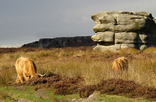
 The views from Curbar Edge and Froggatt Edge are spectacular and worth the climb. In fact there is a car park really close to the edge itself but please don't take that easy shortcut. A veiw like this is so much better when you've earned it.
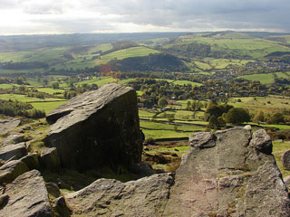
 The return leg of the long version of this walk has another steep climb with the reward of more superb views.
It also passes through Eyam, famous for isloating itself when the black death struck. This ensured that the surrounding villages were spared the disease. During the plague, provisions were left by neighbouring villagers at the town's boundary stone, thus avoiding personal contact. Payment was made by leaving coins in the holes in the stone.
The return leg of the long version of this walk has another steep climb with the reward of more superb views.
It also passes through Eyam, famous for isloating itself when the black death struck. This ensured that the surrounding villages were spared the disease. During the plague, provisions were left by neighbouring villagers at the town's boundary stone, thus avoiding personal contact. Payment was made by leaving coins in the holes in the stone.
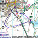
View the route
The link to the right will show you an interactive map with the route shown on it, provided free to you at this level of detail by the lovely folk at OS. The detail on it will be the equivalent of the Landranger map (1:50,000). For the full detail and a map you can carry around the walk with you, you will need an explorer (1:25,000) map. Please use the link below to buy a copy.
blog posts about this walk:
- (long version) http://peacockmedia.blogspot.com/2007/08/froggat-edge.html
- (short version) http://peacockmedia.blogspot.com/2010/10/curbar-edge-and-froggatt-edge-in-autumn.html
This walk uses Ordnance Survey map Explorer OL24 (White Peak)
Unlimited listening to thousands of titles:
