Ordnance Survey Maps
If you want to plan a route and find your way when you get there, then a compass and a 1:25,000 scale (Explorer) map are your friends.
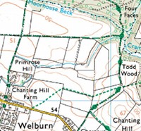
The Explorer map (1:25,000) shows the contours of the land, field boundaries, buildings and churches, viewpoints, and most importantly, the footpaths that you have a right to walk along.
Batteries won't ever run out, it won't stop working if you're under trees or it's very cold.
If you get lost, you should be able to work out where you are, and find a path back to where you should be. If you're not lost, it will show you what's around you and you'll even be able to change your planned route on the hoof if you want to.
Written instructions such as "turn left at the third gate" often leave lots of room for doubt and error, and if you go wrong your only option is to re-trace your steps. Waymarkers are helpful, but can't be relied on either. They become overgrown, fall over, damaged or vandalised. The only sure way find your way is with a map in your hand.
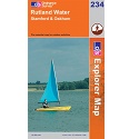
Ordnance Survey Explorer 245 - The National Forest
1:25,000 scale map incuding The National Forest, South Derbyshire, Burton upon Trent, Swadlincote, Ashby de la Zouch, Coalville. Both of South Derbyshire's reservoirs, Foremark Reservoir and Staunton Harold Reservoir. The whole of Ivanhoe Way is clearly marked.
Buy now - below RRP and delivered to your door for free:
£7:49 (UK only at present)
Active map Tough, waterproof, weatherproof edition. More about active maps Below RRP and delivered to your door for free:
£13:49 (UK only at present)
Ordnance Survey Explorer OL1 Dark Peak
1:25,000 scale map The Peak District (north) - Dark Peak Area. Includes Kinder Scout, Bleaklow, Black hill, Win Hill, Lose Hill, Ladybower Reservoir. National Trail Pennine Way. Part of Derwent Valley Heritage Trail (see also Explorer OL24)
Buy now - below RRP and delivered to your door for free:
£7:49 (UK only at present)
Active map Tough, waterproof, weatherproof edition. More about active maps Below RRP and delivered to your door for free:
£13:49 (UK only at present)
Ordnance Survey Explorer OL24 White Peak
1:25,000 scale map The Peak District (south) - White Peak Area. Includes Buxton, Bakewell, Dove Dale, Matlock, Monsal Trail, Pennine Brideleway, High Peak Trail, Tissington Trail. Part of Derwent Valley Heritage Trail (see also Explorer OL1)
Regular paper version available shortly
Active map Tough, waterproof, weatherproof edition. More about active maps Below RRP and delivered to your door for free:
£13:49 (UK only at present)
Ordnance Survey Explorer 234 Rutland Water
1:25,000 scale map Rutland Water. Includes Stamford and Oakham.
Buy now - below RRP and delivered to your door for free:
£7:49 (UK only at present)
Ordnance Survey Explorer OL17 Snowdon
1:25,000 scale map Snowdon / Yr Wyddfa. Conwy Valley / Dyffrn Conwy.
Buy now - below RRP and delivered to your door for free:
£7:49 (UK only at present)
National Trail Guide Offa's Dyke Path North
Official guide, containing 1:25,000 mapping for this half of the National Trail. Read my review of this book and read more about the National Trail Offa's Dyke Path North
Buy now, delivered to your door for free: £12:99